In this Instagram age, there’s always a temptation to explore only the most popular and well-traveled sites. We’re lured by enticing, sometimes carefully manipulated, photos and yearn to go. Nothing wrong with visiting Arizona’s iconic trails. They’re popular for good reason. But this diverse state has so much more to offer. How about taking a path that’s actually off the beaten path?
Part of the great joy of hiking is the sense of exploration. Seek out unfamiliar trails. Leave the crowds and the algorithm behind and venture into the unknown. Discover special places all on your own. Forge a personal connection with the landscape and make lasting memories thanks to these secret Arizona trails.
These are the six best Arizona hikes you probably never heard of.
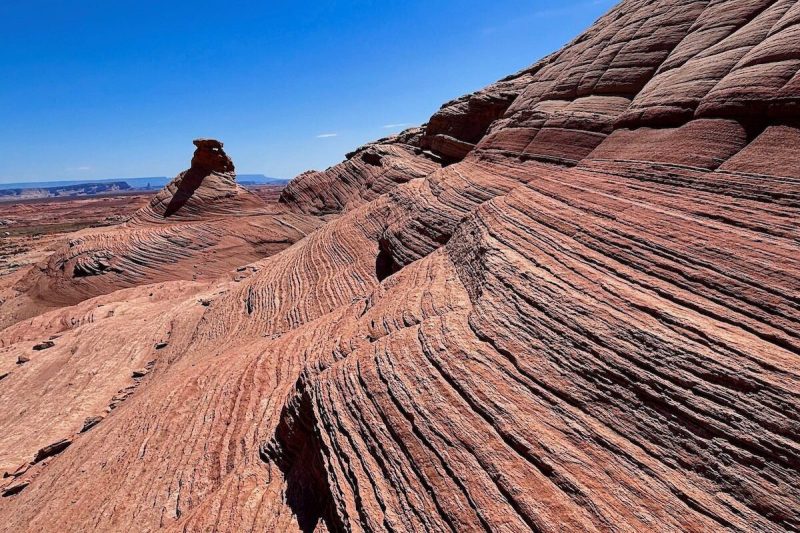
Beehive Trail, Page
Traversing a large patch of swirling, swooping sandstone, this is often called the New Wave Trail, for its resemblance to the legendary formation in the nearby Vermilion Cliffs National Monument. Yet the Beehive is easy to explore. It makes a family-friendly loop amid its enchanting terrain and even offers a few glimpses of Lake Powell.
The trail flows nicely over the undulating landscape, never steep, never too edgy. A short side path at a “Y” leads to an impressive overlook. The Beehive hugs a shoulder of stone as it circles a large outcrop formation. Ancient winds have left their fingerprints all over this trail, sculpting long swooping lines through the sandstone. No doubt that pattern of swoops and swirls invites comparison to the original and more elusive Wave. But no hard-to-acquire permit is required for the peaceful Beehive.
Where: From Page, drive north on US 89 to just past the Carl Hayden Visitor Center. Turn left onto a dirt road leading to Beehives Campground (just before the south entrance to Wahweap Marina). Trailhead parking is on the left, directly across from the Beehives campsites.
Cost: Admission to Glen Canyon National Recreation Area is $30 per week for a passenger vehicle.
Difficulty: Easy.
Length: 1.5 miles round-trip, 2 miles with the side trip.
Details: 928-608-6200, nps.gov/glca.
Lee Cly Trail, Monument Valley Navajo Tribal Park
This pathway makes a 2.1-mile loop across rolling sandy hills with excellent views of Mitchell Butte, Mitchell Mesa and Grey Whiskers Butte. Starting from the southside of the View Hotel, the trail stays mostly level but deep sand provides a bit of a workout. The trail’s namesake Lee Cly was born in Monument Valley and went on to become the longest serving ranger in the tribal park’s history.
The Mesa Rim Trail branches off and you can extend your outing by following it uphill. It makes a short (0.7 miles one-way) but steep climb up the shoulder of the mesa above the hotel. The elevated perch offers a good vantage point for far-ranging vistas. But be alert. It’s hard to tell exactly where the official trail ends. Some social pathways keep going up and the footing becomes less stable the higher you go. Navajo guides are not required for these trails.
Where: From Kayenta, drive north on US 163 for 23 miles and turn right into Monument Valley Tribal Park. Trail begins 0.4 miles north of visitor center from the campground.
Cost: Park admission is $8 per person.
Difficulty: Moderate.
Length: 2.1 miles round-trip, longer if Mesa Rim is explored.
Details: 435-727-5870, navajonationparks.org.
Wedge Hill Trail, Parker
Perched on the banks of the Colorado River, River Island State Park, is easy to overlook as just a campground for snowbirds and river rats. But the Wedge Hill Trail makes this a must-stop. The short climb up Wedge Hill may be the most scenic half-mile in the state park system.
River Island is a speck of a park, nestled in a small sloping bowl at the base of stark mountains that rise from the water’s edge. It’s a beautiful setting and with only 37 campsites, this is about as intimate an experience with the river as you can get. Starting from beside the boat launch ramp, Wedge Hill Trail scrambles up into the bluffs overlooking a bend in the river. The views are absolutely mesmerizing, with sun glinting off the blue-green water, framed by a cluster of sudden mountains. This is hard-edged country, bare rock and sharp angles and the vistas change every few steps. There are a few well-placed benches early on where you can sit and admire the dramatic panoramas.
Where: From Parker, drive north on US 95 for 13 miles.
Cost: Park admission is $10 per vehicle.
Difficulty: Easy.
Length: 1-mile round trip.
Details: 928-667-3386, azstateparks.com/river-island.
Painted Desert Trail, Yuma
The Imperial National Wildlife Refuge harbors an intriguing mix of river, marshy wetlands and backwater lakes bracketed by stark desert. Yet the Painted Desert Trail cuts through a corner of the landscape so exotic and colorful it could double as a set for a Martian film shoot. This unusual terrain resulted from volcanic fury some 20 to 30 million years ago. A variety of minerals tinted the cooling ash and created an intriguing palette of hues. Then long-term erosion shaped the hills and hoodoos.
Painted Desert Trail makes a 1.3-mile loop into the outback, following a wash, crossing a ridge and then tracing another sandy wash back to the trailhead. It’s a lavishly fractured terrain, weaving among colorful mounds that look like petrified sand dunes. The walking is easy with only a short climb to the ridgeline for some fine views, a mosaic of desert patterns, plus the wet knife of the river carving a verdant slice in the distance. Grab a trail brochure at the visitor center for details of this intriguing hike.
Where: From Yuma, travel north on US 95 for 24 miles to Martinez Lake Road. Turn left and continue 10 miles to Red Cloud Mine Road. Turn right and follow signs 3.5 miles to the visitor center.
Cost: Free.
Difficulty: Easy.
Length: 1.3 miles round-trip.
Details: 928-783-3371, fws.gov/refuge/imperial.
Linda Vista Trail, Tucson
While no secret to the residents of Oro Valley, Linda Vista Trail flies under the radar amid Tucson’s wealth of great hiking opportunities. Linda Vista makes a ragged loop through the desert landscape, with inner segments that allow hikers to customize their outing. If you stick to the outer segments the hike totals 2.8 miles according to the trailhead map. To get most of the climbing out of the way early, take the trail clockwise.
It’s a twisting, rocky pathway but easy to follow. This is a great route just before sunset when soft golden light swabs the peaks of the Catalina Mountains overhead. Views stretch back across the city as you reach the high point of the loop near the edge of a shallow canyon. An unmaintained trail points the way to the top of Pusch Peak but this steep, unstable path should only be attempted by experienced hikers. Also, that trail may be closed in winter due to bighorn sheep lambing season. The Linda Vista angles back downhill to the trailhead.
Where: Take Oracle Road north from Tucson. Turn right on Linda Vista Drive. Trailhead is on the right.
Cost: Free.
Difficulty: Moderate.
Length: 2.8 miles round-trip.
Details: 520-749-8700, fs.usda.gov/r03/coronado.
Red Mountain Trail, Flagstaff
The short, easy trail travels through scenic woodlands before plunging into the mystical gullet of a volcano. Unlike most symmetrical cinder cones, Red Mountain is a haphazard U-shape, with an amphitheater carved from the northeast flank, leaving behind a ragged assortment of hoodoos.
The trail starts along an old road then dips into the bed of a wash. After a mile the streambed squeezes between towers of black cinders. A ladder climbs over a stone wall and you are engulfed in a wonderland of gnawed spires, twisted pillars and contorted walls bubbled with trapped gasses. A web of pathways weaves among the clustered hoodoos. It’s like a hobbit-sized Bryce Canyon, vivid and endlessly entertaining. Yank the kids off the swing set and let them explore a natural playground.
Where: From Flagstaff, drive northwest on Highway 180 for 25 miles. Near milepost 247, turn left at the forest service sign. Take the dirt road a quarter mile to parking area.
Cost: Free.
Difficulty: Easy.
Length: 3 miles round-trip.
Details: 928-526-0866, fs.usda.gov/r03/coconino.
Reporting by Roger Naylor, Special for The Republic